


Fagnes de Sourbroodt 18km

DHeusse
User
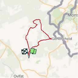

Length
18.4 km

Max alt
670 m

Uphill gradient
367 m
Km-Effort
23 km

Min alt
536 m

Downhill gradient
371 m
Boucle
Yes
Creation date :
2019-02-08 15:25:59.171
Updated on :
2019-02-08 15:48:29.38
5h01
Difficulty : Very difficult

FREE GPS app for hiking
 SityTrail
IGN / Geographical institutes
SityTrail Plus
The world is yours!
About
Trail Walking of 18.4 km to be discovered at Wallonia, Liège, Waimes. This trail is proposed by DHeusse.
Positioning
Country:
Belgium
Region :
Wallonia
Department/Province :
Liège
Municipality :
Waimes
Location:
Robertville
Start:(Dec)
Start:(UTM)
296520 ; 5597309 (32U) N.
Comments
Les Fagnes dans toutes leurs splendeurs. Merci!