


hhhh

trailer38
User
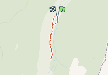

Length
2.3 km

Max alt
1321 m

Uphill gradient
186 m
Km-Effort
4.7 km

Min alt
1127 m

Downhill gradient
178 m
Boucle
Yes
Creation date :
2019-02-09 14:25:41.79
Updated on :
2019-02-09 16:04:51.69
1h37
Difficulty : Very easy

FREE GPS app for hiking
 SityTrail
IGN / Geographical institutes
SityTrail Plus
The world is yours!
About
Trail Walking of 2.3 km to be discovered at Auvergne-Rhône-Alpes, Isère, Saint-Christophe-sur-Guiers. This trail is proposed by trailer38.
Positioning
Country:
France
Region :
Auvergne-Rhône-Alpes
Department/Province :
Isère
Municipality :
Saint-Christophe-sur-Guiers
Location:
Unknown
Start:(Dec)
Start:(UTM)
719092 ; 5031234 (31T) N.
Comments