


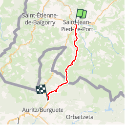
10 - Saint Jean de Pied de Port - Roncevaux

norihtom
User

Length
25 km

Max alt
1427 m

Uphill gradient
1384 m
Km-Effort
41 km

Min alt
161 m

Downhill gradient
613 m
Boucle
No
Creation date :
2019-02-12 00:05:19.732
Updated on :
2019-02-12 14:23:46.262
8h51
Difficulty : Very difficult

FREE GPS app for hiking
 SityTrail
IGN / Geographical institutes
SityTrail Plus
The world is yours!
About
Trail Walking of 25 km to be discovered at New Aquitaine, Pyrénées-Atlantiques, Uhart-Cize. This trail is proposed by norihtom.
Positioning
Country:
France
Region :
New Aquitaine
Department/Province :
Pyrénées-Atlantiques
Municipality :
Uhart-Cize
Location:
Unknown
Start:(Dec)
Start:(UTM)
642697 ; 4780585 (30T) N.
Comments