


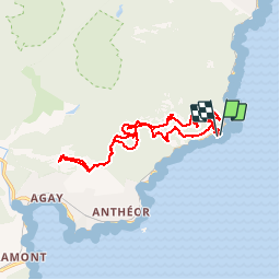
Rastel d'Agay par la pointe de l'observatoire Estérel

verotrail
User

Length
17.6 km

Max alt
339 m

Uphill gradient
710 m
Km-Effort
27 km

Min alt
27 m

Downhill gradient
714 m
Boucle
Yes
Creation date :
2019-02-13 11:37:01.437
Updated on :
2019-03-15 10:02:08.705
--
Difficulty : Difficult

FREE GPS app for hiking
 SityTrail
IGN / Geographical institutes
SityTrail Plus
The world is yours!
About
Trail On foot of 17.6 km to be discovered at Provence-Alpes-Côte d'Azur, Var, Saint-Raphaël. This trail is proposed by verotrail.
Positioning
Country:
France
Region :
Provence-Alpes-Côte d'Azur
Department/Province :
Var
Municipality :
Saint-Raphaël
Location:
Unknown
Start:(Dec)
Start:(UTM)
331511 ; 4812821 (32T) N.
Comments