


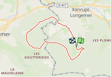
Routes forestières Xonrupt

lepompi
User

Length
7.3 km

Max alt
993 m

Uphill gradient
208 m
Km-Effort
10.1 km

Min alt
791 m

Downhill gradient
211 m
Boucle
Yes
Creation date :
2019-02-13 16:48:23.479
Updated on :
2021-06-24 18:55:52.669
--
Difficulty : Medium

FREE GPS app for hiking
 SityTrail
IGN / Geographical institutes
SityTrail Plus
The world is yours!
About
Trail On foot of 7.3 km to be discovered at Grand Est, Vosges, Xonrupt-Longemer. This trail is proposed by lepompi.
Description
A faire dans la neige ! Prévoir raquettes pour passages peu fréquentés
difficulté moyenne!
beaux panoramas
Photos

Positioning
Country:
France
Region :
Grand Est
Department/Province :
Vosges
Municipality :
Xonrupt-Longemer
Location:
Unknown
Start:(Dec)
Start:(UTM)
345367 ; 5325954 (32U) N.
Comments