


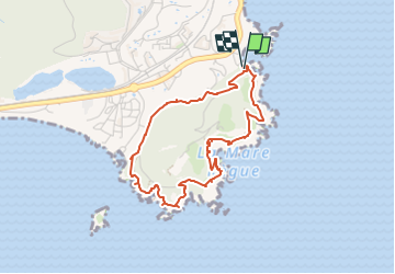
Agay retour parking

verotrail
User

Length
4.2 km

Max alt
78 m

Uphill gradient
150 m
Km-Effort
6.2 km

Min alt
4 m

Downhill gradient
150 m
Boucle
Yes
Creation date :
2019-02-14 22:04:49.117
Updated on :
2019-02-14 22:08:14.164
--
Difficulty : Very easy

FREE GPS app for hiking
 SityTrail
IGN / Geographical institutes
SityTrail Plus
The world is yours!
About
Trail On foot of 4.2 km to be discovered at Provence-Alpes-Côte d'Azur, Var, Saint-Raphaël. This trail is proposed by verotrail.
Positioning
Country:
France
Region :
Provence-Alpes-Côte d'Azur
Department/Province :
Var
Municipality :
Saint-Raphaël
Location:
Unknown
Start:(Dec)
Start:(UTM)
326590 ; 4809619 (32T) N.
Comments