


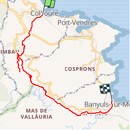
Collioure, Banyuls par la Madeloc

rene06530
User

Length
14.9 km

Max alt
637 m

Uphill gradient
732 m
Km-Effort
25 km

Min alt
3 m

Downhill gradient
743 m
Boucle
No
Creation date :
2019-02-15 13:47:31.94
Updated on :
2019-02-15 13:53:50.06
--
Difficulty : Difficult

FREE GPS app for hiking
 SityTrail
IGN / Geographical institutes
SityTrail Plus
The world is yours!
About
Trail On foot of 14.9 km to be discovered at Occitania, Pyrénées-Orientales, Collioure. This trail is proposed by rene06530.
Description
Collioure, notre dame de la consolation, la Madeloc, col du Gasgon, notre dame de la Salette, Banyuls.
Positioning
Country:
France
Region :
Occitania
Department/Province :
Pyrénées-Orientales
Municipality :
Collioure
Location:
Unknown
Start:(Dec)
Start:(UTM)
506759 ; 4708016 (31T) N.
Comments