


la cheneraie 2

cps46
User
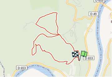

Length
5.4 km

Max alt
275 m

Uphill gradient
132 m
Km-Effort
7.1 km

Min alt
172 m

Downhill gradient
133 m
Boucle
Yes
Creation date :
2014-12-10 00:00:00.0
Updated on :
2014-12-10 00:00:00.0
--
Difficulty : Unknown

FREE GPS app for hiking
 SityTrail
IGN / Geographical institutes
SityTrail Plus
The world is yours!
About
Trail Running of 5.4 km to be discovered at Occitania, Lot, Saint-Géry-Vers. This trail is proposed by cps46.
Description
moyen
Positioning
Country:
France
Region :
Occitania
Department/Province :
Lot
Municipality :
Saint-Géry-Vers
Location:
Vers
Start:(Dec)
Start:(UTM)
384364 ; 4925259 (31T) N.
Comments