


20190216

BenPep
User
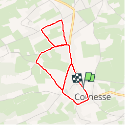

Length
3.8 km

Max alt
284 m

Uphill gradient
38 m
Km-Effort
4.3 km

Min alt
262 m

Downhill gradient
39 m
Boucle
Yes
Creation date :
2019-02-16 11:12:32.829
Updated on :
2019-02-16 12:02:12.105
49m
Difficulty : Easy

FREE GPS app for hiking
 SityTrail
IGN / Geographical institutes
SityTrail Plus
The world is yours!
About
Trail Walking of 3.8 km to be discovered at Wallonia, Liège, Pepinster. This trail is proposed by BenPep.
Positioning
Country:
Belgium
Region :
Wallonia
Department/Province :
Liège
Municipality :
Pepinster
Location:
Cornesse
Start:(Dec)
Start:(UTM)
697493 ; 5606365 (31U) N.
Comments