


Base de Cergy

Djaie60
User
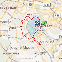

Length
10.7 km

Max alt
96 m

Uphill gradient
146 m
Km-Effort
12.6 km

Min alt
17 m

Downhill gradient
146 m
Boucle
Yes
Creation date :
2019-02-16 12:37:59.429
Updated on :
2019-02-16 12:39:09.196
2h45
Difficulty : Difficult

FREE GPS app for hiking
 SityTrail
IGN / Geographical institutes
SityTrail Plus
The world is yours!
About
Trail Walking of 10.7 km to be discovered at Ile-de-France, Val-d'Oise, Cergy. This trail is proposed by Djaie60.
Positioning
Country:
France
Region :
Ile-de-France
Department/Province :
Val-d'Oise
Municipality :
Cergy
Location:
Unknown
Start:(Dec)
Start:(UTM)
431068 ; 5431142 (31U) N.
Comments