


MASSONS

RD78-38
User
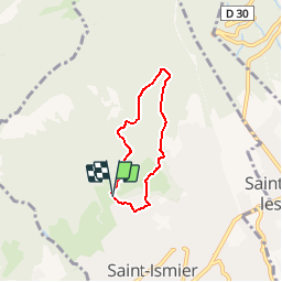

Length
4.6 km

Max alt
753 m

Uphill gradient
307 m
Km-Effort
8.7 km

Min alt
425 m

Downhill gradient
315 m
Boucle
Yes
Creation date :
2019-02-17 10:41:09.091
Updated on :
2019-02-17 11:11:21.799
--
Difficulty : Very easy

FREE GPS app for hiking
 SityTrail
IGN / Geographical institutes
SityTrail Plus
The world is yours!
About
Trail On foot of 4.6 km to be discovered at Auvergne-Rhône-Alpes, Isère, Saint-Ismier. This trail is proposed by RD78-38.
Positioning
Country:
France
Region :
Auvergne-Rhône-Alpes
Department/Province :
Isère
Municipality :
Saint-Ismier
Location:
Unknown
Start:(Dec)
Start:(UTM)
721272 ; 5015300 (31T) N.
Comments