


la glacière de pivaut

Coryphene
User
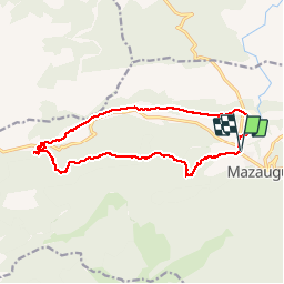

Length
15 km

Max alt
697 m

Uphill gradient
379 m
Km-Effort
20 km

Min alt
369 m

Downhill gradient
379 m
Boucle
Yes
Creation date :
2019-02-17 09:47:44.739
Updated on :
2019-09-24 15:15:50.276
6h46
Difficulty : Very easy

FREE GPS app for hiking
 SityTrail
IGN / Geographical institutes
SityTrail Plus
The world is yours!
About
Trail Walking of 15 km to be discovered at Provence-Alpes-Côte d'Azur, Var, Mazaugues. This trail is proposed by Coryphene.
Positioning
Country:
France
Region :
Provence-Alpes-Côte d'Azur
Department/Province :
Var
Municipality :
Mazaugues
Location:
Unknown
Start:(Dec)
Start:(UTM)
736158 ; 4804008 (31T) N.
Comments