


20190218-montygny canteleu derniere mouture

doudet
User
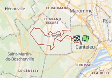

Length
14 km

Max alt
149 m

Uphill gradient
207 m
Km-Effort
16.7 km

Min alt
82 m

Downhill gradient
207 m
Boucle
Yes
Creation date :
2019-02-18 14:20:02.259
Updated on :
2019-02-18 14:23:20.801
--
Difficulty : Medium

FREE GPS app for hiking
 SityTrail
IGN / Geographical institutes
SityTrail Plus
The world is yours!
About
Trail On foot of 14 km to be discovered at Normandy, Seine-Maritime, Canteleu. This trail is proposed by doudet.
Positioning
Country:
France
Region :
Normandy
Department/Province :
Seine-Maritime
Municipality :
Canteleu
Location:
Unknown
Start:(Dec)
Start:(UTM)
357279 ; 5479561 (31U) N.
Comments