Lavillertertre 12.6km

Djaie60
User
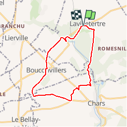

Length
12.7 km

Max alt
126 m

Uphill gradient
161 m
Km-Effort
14.8 km

Min alt
67 m

Downhill gradient
162 m
Boucle
Yes
Creation date :
2019-02-18 17:02:53.111
Updated on :
2019-02-18 17:06:43.611
--
Difficulty : Medium

FREE GPS app for hiking
 SityTrail
IGN / Geographical institutes
SityTrail Plus
The world is yours!
About
Trail On foot of 12.7 km to be discovered at Hauts-de-France, Oise, Lavilletertre. This trail is proposed by Djaie60.
Positioning
Country:
France
Region :
Hauts-de-France
Department/Province :
Oise
Municipality :
Lavilletertre
Location:
Unknown
Start:(Dec)
Start:(UTM)
421899 ; 5449736 (31U) N.
Comments