


Château de la Reine Blanche, étangs de Commelle, Courteuil, Chantilly

philberard95
User
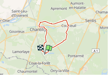

Length
21 km

Max alt
86 m

Uphill gradient
211 m
Km-Effort
24 km

Min alt
37 m

Downhill gradient
211 m
Boucle
Yes
Creation date :
2019-02-21 09:40:49.64
Updated on :
2023-01-11 13:08:58.411
5h06
Difficulty : Easy

FREE GPS app for hiking
 SityTrail
IGN / Geographical institutes
SityTrail Plus
The world is yours!
About
Trail Nordic walking of 21 km to be discovered at Hauts-de-France, Oise, Coye-la-Forêt. This trail is proposed by philberard95.
Positioning
Country:
France
Region :
Hauts-de-France
Department/Province :
Oise
Municipality :
Coye-la-Forêt
Location:
Unknown
Start:(Dec)
Start:(UTM)
462052 ; 5444845 (31U) N.
Comments