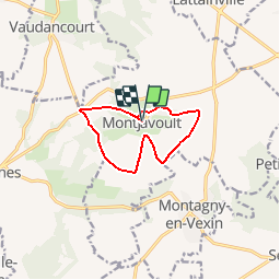
Montjavoult

Djaie60
User

Length
8.5 km

Max alt
202 m

Uphill gradient
160 m
Km-Effort
10.7 km

Min alt
118 m

Downhill gradient
160 m
Boucle
Yes
Creation date :
2019-02-21 18:34:27.555
Updated on :
2019-02-21 18:36:09.231
2h18
Difficulty : Medium

FREE GPS app for hiking
 SityTrail
IGN / Geographical institutes
SityTrail Plus
The world is yours!
About
Trail Walking of 8.5 km to be discovered at Hauts-de-France, Oise, Montjavoult. This trail is proposed by Djaie60.
Positioning
Country:
France
Region :
Hauts-de-France
Department/Province :
Oise
Municipality :
Montjavoult
Location:
Unknown
Start:(Dec)
Start:(UTM)
411473 ; 5451977 (31U) N.
Comments