


st Jean Cap Ferrat Tranquil

nicochproun
User
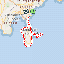

Length
12 km

Max alt
42 m

Uphill gradient
217 m
Km-Effort
14.9 km

Min alt
-1 m

Downhill gradient
218 m
Boucle
Yes
Creation date :
2019-02-22 10:04:50.46
Updated on :
2019-02-22 11:47:56.014
1h42
Difficulty : Very easy

FREE GPS app for hiking
 SityTrail
IGN / Geographical institutes
SityTrail Plus
The world is yours!
About
Trail Running of 12 km to be discovered at Provence-Alpes-Côte d'Azur, Maritime Alps, Beaulieu-sur-Mer. This trail is proposed by nicochproun.
Positioning
Country:
France
Region :
Provence-Alpes-Côte d'Azur
Department/Province :
Maritime Alps
Municipality :
Beaulieu-sur-Mer
Location:
Unknown
Start:(Dec)
Start:(UTM)
365584 ; 4840361 (32T) N.
Comments