


9614882-Hiv2019_P3_V7

PhilippeC54
User
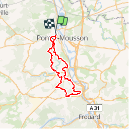

Length
47 km

Max alt
347 m

Uphill gradient
935 m
Km-Effort
59 km

Min alt
175 m

Downhill gradient
931 m
Boucle
No
Creation date :
2019-02-24 19:56:36.956
Updated on :
2019-03-02 07:33:17.164
--
Difficulty : Unknown

FREE GPS app for hiking
 SityTrail
IGN / Geographical institutes
SityTrail Plus
The world is yours!
About
Trail Mountain bike of 47 km to be discovered at Grand Est, Meurthe-et-Moselle, Pont-à-Mousson. This trail is proposed by PhilippeC54.
Positioning
Country:
France
Region :
Grand Est
Department/Province :
Meurthe-et-Moselle
Municipality :
Pont-à-Mousson
Location:
Unknown
Start:(Dec)
Start:(UTM)
282947 ; 5422002 (32U) N.
Comments