


RandoGuide G

PhilippeC54
User
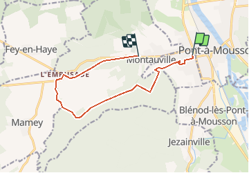

Length
11 km

Max alt
349 m

Uphill gradient
244 m
Km-Effort
14.1 km

Min alt
185 m

Downhill gradient
197 m
Boucle
No
Creation date :
2019-02-25 09:30:31.415
Updated on :
2020-02-19 07:37:08.911
1h12
Difficulty : Easy

FREE GPS app for hiking
 SityTrail
IGN / Geographical institutes
SityTrail Plus
The world is yours!
About
Trail Mountain bike of 11 km to be discovered at Grand Est, Meurthe-et-Moselle, Maidières. This trail is proposed by PhilippeC54.
Description
RandoGuide Boussole Puvenelle 2019
Positioning
Country:
France
Region :
Grand Est
Department/Province :
Meurthe-et-Moselle
Municipality :
Maidières
Location:
Unknown
Start:(Dec)
Start:(UTM)
283229 ; 5420646 (32U) N.
Comments