


Bois de Callian Tanneron 3643 ET

verotrail
User
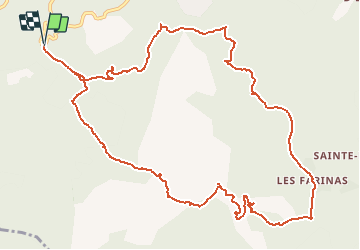

Length
14.6 km

Max alt
470 m

Uphill gradient
491 m
Km-Effort
21 km

Min alt
197 m

Downhill gradient
491 m
Boucle
Yes
Creation date :
2019-02-25 18:03:49.1
Updated on :
2019-02-25 18:04:54.412
--
Difficulty : Medium

FREE GPS app for hiking
 SityTrail
IGN / Geographical institutes
SityTrail Plus
The world is yours!
About
Trail On foot of 14.6 km to be discovered at Provence-Alpes-Côte d'Azur, Var, Tanneron. This trail is proposed by verotrail.
Positioning
Country:
France
Region :
Provence-Alpes-Côte d'Azur
Department/Province :
Var
Municipality :
Tanneron
Location:
Unknown
Start:(Dec)
Start:(UTM)
324193 ; 4827418 (32T) N.
Comments
quand on aime,on ne compte pas