


balazuc 2

Coux
User
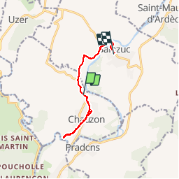

Length
9.7 km

Max alt
227 m

Uphill gradient
229 m
Km-Effort
12.8 km

Min alt
129 m

Downhill gradient
254 m
Boucle
No
Creation date :
2019-02-26 09:52:01.432
Updated on :
2019-02-27 10:33:17.896
2h36
Difficulty : Easy

FREE GPS app for hiking
 SityTrail
IGN / Geographical institutes
SityTrail Plus
The world is yours!
About
Trail Trail of 9.7 km to be discovered at Auvergne-Rhône-Alpes, Ardèche, Chauzon. This trail is proposed by Coux.
Positioning
Country:
France
Region :
Auvergne-Rhône-Alpes
Department/Province :
Ardèche
Municipality :
Chauzon
Location:
Unknown
Start:(Dec)
Start:(UTM)
607960 ; 4927549 (31T) N.
Comments