


DIMANCHE 14 JUILLET 2013

Tollard
User
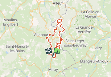

Length
56 km

Max alt
911 m

Uphill gradient
2162 m
Km-Effort
85 km

Min alt
321 m

Downhill gradient
2165 m
Boucle
Yes
Creation date :
2015-07-07 00:00:00.0
Updated on :
2015-07-07 00:00:00.0
5h17
Difficulty : Difficult

FREE GPS app for hiking
 SityTrail
IGN / Geographical institutes
SityTrail Plus
The world is yours!
About
Trail Mountain bike of 56 km to be discovered at Bourgogne-Franche-Comté, Nièvre, Larochemillay. This trail is proposed by Tollard.


Positioning
Country:
France
Region :
Bourgogne-Franche-Comté
Department/Province :
Nièvre
Municipality :
Larochemillay
Location:
Unknown
Start:(Dec)
Start:(UTM)
576288 ; 5192060 (31T) N.
Comments
parcours physique, mais de toute beauté
LE SUD MORVAN DANS TOUTE SA SPLENDEUR.ATTENTION / UN BON ENTRAINEMENT S'IMPOSE