


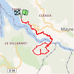
Plage de Savel - Passerelle du Drac - Point de vue côte 676

maupassant38
User

Length
10.3 km

Max alt
667 m

Uphill gradient
439 m
Km-Effort
16.1 km

Min alt
470 m

Downhill gradient
437 m
Boucle
Yes
Creation date :
2019-02-27 10:59:19.716
Updated on :
2019-02-27 18:58:12.774
3h00
Difficulty : Medium

FREE GPS app for hiking
 SityTrail
IGN / Geographical institutes
SityTrail Plus
The world is yours!
About
Trail Walking of 10.3 km to be discovered at Auvergne-Rhône-Alpes, Isère, Mayres-Savel. This trail is proposed by maupassant38.
Positioning
Country:
France
Region :
Auvergne-Rhône-Alpes
Department/Province :
Isère
Municipality :
Mayres-Savel
Location:
Unknown
Start:(Dec)
Start:(UTM)
712543 ; 4972996 (31T) N.
Comments