


Brigittenschloss par Gaishölen Wasserfall et Straubenhöf Muhl

pjjrevrard
User
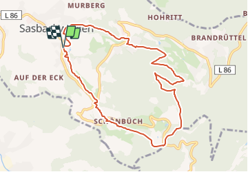

Length
9.3 km

Max alt
777 m

Uphill gradient
535 m
Km-Effort
16.4 km

Min alt
257 m

Downhill gradient
534 m
Boucle
Yes
Creation date :
2014-12-10 00:00:00.0
Updated on :
2014-12-10 00:00:00.0
3h02
Difficulty : Medium

FREE GPS app for hiking
 SityTrail
IGN / Geographical institutes
SityTrail Plus
The world is yours!
About
Trail Walking of 9.3 km to be discovered at Baden-Württemberg, Ortenaukreis, Sasbachwalden. This trail is proposed by pjjrevrard.
Positioning
Country:
Germany
Region :
Baden-Württemberg
Department/Province :
Ortenaukreis
Municipality :
Sasbachwalden
Location:
Unknown
Start:(Dec)
Start:(UTM)
435871 ; 5385069 (32U) N.
Comments