


chapelle st ferreol

leroj73
User
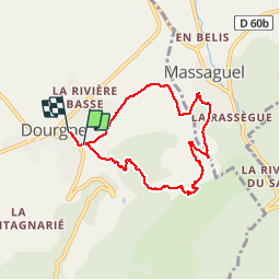

Length
7.2 km

Max alt
535 m

Uphill gradient
332 m
Km-Effort
11.6 km

Min alt
249 m

Downhill gradient
323 m
Boucle
No
Creation date :
2019-03-02 14:48:50.591
Updated on :
2019-03-02 17:24:16.206
2h33
Difficulty : Medium

FREE GPS app for hiking
 SityTrail
IGN / Geographical institutes
SityTrail Plus
The world is yours!
About
Trail Walking of 7.2 km to be discovered at Occitania, Tarn, Dourgne. This trail is proposed by leroj73.
Description
une montée d entrée qui offre des vues hors du temps et du bruit de toute beauté
Positioning
Country:
France
Region :
Occitania
Department/Province :
Tarn
Municipality :
Dourgne
Location:
Unknown
Start:(Dec)
Start:(UTM)
430530 ; 4814878 (31T) N.
Comments