


Lac de L'Avellan/Bge Malpasset

Michelisabelle
User

Length
14.9 km

Max alt
314 m

Uphill gradient
358 m
Km-Effort
19.7 km

Min alt
38 m

Downhill gradient
356 m
Boucle
Yes
Creation date :
2019-03-04 17:52:18.044
Updated on :
2019-03-04 17:55:29.339
5h00
Difficulty : Medium

FREE GPS app for hiking
 SityTrail
IGN / Geographical institutes
SityTrail Plus
The world is yours!
About
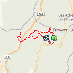
Trail On foot of 14.9 km to be discovered at Provence-Alpes-Côte d'Azur, Var, Fréjus. This trail is proposed by Michelisabelle.
Positioning
Country:
France
Region :
Provence-Alpes-Côte d'Azur
Department/Province :
Var
Municipality :
Fréjus
Location:
Unknown
Start:(Dec)
Start:(UTM)
321610 ; 4818918 (32T) N.
Comments