


Lac de Monteynard - Pas du Brion

maupassant38
User
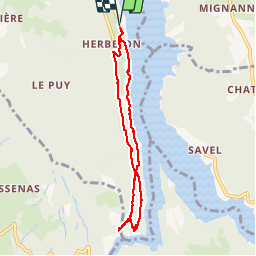

Length
7.2 km

Max alt
695 m

Uphill gradient
268 m
Km-Effort
10.8 km

Min alt
485 m

Downhill gradient
268 m
Boucle
Yes
Creation date :
2019-03-06 09:56:52.659
Updated on :
2019-03-07 17:48:53.924
2h02
Difficulty : Easy

FREE GPS app for hiking
 SityTrail
IGN / Geographical institutes
SityTrail Plus
The world is yours!
About
Trail Walking of 7.2 km to be discovered at Auvergne-Rhône-Alpes, Isère, Treffort. This trail is proposed by maupassant38.
Positioning
Country:
France
Region :
Auvergne-Rhône-Alpes
Department/Province :
Isère
Municipality :
Treffort
Location:
Unknown
Start:(Dec)
Start:(UTM)
711086 ; 4975086 (31T) N.
Comments