


Chamrousse - L'Arselle

maupassant38
User
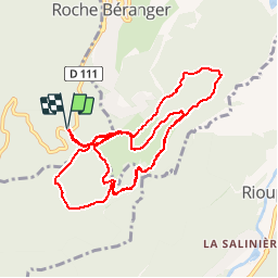

Length
12.1 km

Max alt
1730 m

Uphill gradient
310 m
Km-Effort
16.3 km

Min alt
1571 m

Downhill gradient
310 m
Boucle
Yes
Creation date :
2019-03-07 12:30:23.266
Updated on :
2019-03-07 17:46:28.709
1h34
Difficulty : Easy

FREE GPS app for hiking
 SityTrail
IGN / Geographical institutes
SityTrail Plus
The world is yours!
About
Trail Cross-country skiing of 12.1 km to be discovered at Auvergne-Rhône-Alpes, Isère, Vaulnaveys-le-Haut. This trail is proposed by maupassant38.
Positioning
Country:
France
Region :
Auvergne-Rhône-Alpes
Department/Province :
Isère
Municipality :
Vaulnaveys-le-Haut
Location:
Unknown
Start:(Dec)
Start:(UTM)
725737 ; 4997999 (31T) N.
Comments