


Conques - Decazeville

norihtom
User
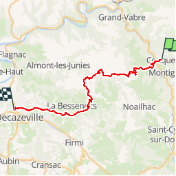

Length
21 km

Max alt
583 m

Uphill gradient
722 m
Km-Effort
31 km

Min alt
207 m

Downhill gradient
797 m
Boucle
No
Creation date :
2014-12-10 00:00:00.0
Updated on :
2014-12-10 00:00:00.0
6h24
Difficulty : Medium

FREE GPS app for hiking
 SityTrail
IGN / Geographical institutes
SityTrail Plus
The world is yours!
About
Trail Walking of 21 km to be discovered at Occitania, Aveyron, Conques-en-Rouergue. This trail is proposed by norihtom.
Positioning
Country:
France
Region :
Occitania
Department/Province :
Aveyron
Municipality :
Conques-en-Rouergue
Location:
Unknown
Start:(Dec)
Start:(UTM)
452171 ; 4938589 (31T) N.
Comments