


Forêt d'Avaux 13,5 km

jeanmarcMasson
User GUIDE
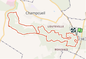

Length
13.5 km

Max alt
153 m

Uphill gradient
236 m
Km-Effort
16.6 km

Min alt
85 m

Downhill gradient
237 m
Boucle
Yes
Creation date :
2019-03-08 10:03:11.749
Updated on :
2019-03-08 14:19:47.935
4h15
Difficulty : Medium

FREE GPS app for hiking
 SityTrail
IGN / Geographical institutes
SityTrail Plus
The world is yours!
About
Trail Walking of 13.5 km to be discovered at Ile-de-France, Essonne, Champcueil. This trail is proposed by jeanmarcMasson.
Positioning
Country:
France
Region :
Ile-de-France
Department/Province :
Essonne
Municipality :
Champcueil
Location:
Unknown
Start:(Dec)
Start:(UTM)
461574 ; 5372446 (31U) N.
Comments