


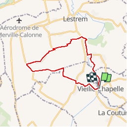
SityTrail - 12km La Fosse à Lestrem

Blourouce
User

Length
11.2 km

Max alt
21 m

Uphill gradient
41 m
Km-Effort
11.7 km

Min alt
14 m

Downhill gradient
39 m
Boucle
Yes
Creation date :
2019-03-08 17:46:24.541
Updated on :
2019-09-17 08:47:04.753
2h48
Difficulty : Difficult

FREE GPS app for hiking
 SityTrail
IGN / Geographical institutes
SityTrail Plus
The world is yours!
About
Trail Walking of 11.2 km to be discovered at Hauts-de-France, Pas-de-Calais, Vieille-Chapelle. This trail is proposed by Blourouce.
Description
randonnée de 12km au départ de La Fosse à Lestrem, vers le paradis !
mais ne rêvez pas.
Positioning
Country:
France
Region :
Hauts-de-France
Department/Province :
Pas-de-Calais
Municipality :
Vieille-Chapelle
Location:
Unknown
Start:(Dec)
Start:(UTM)
478929 ; 5604377 (31U) N.
Comments