


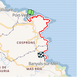
Port vendres à Banyuls par cap Béar.

rene06530
User

Length
11.1 km

Max alt
89 m

Uphill gradient
259 m
Km-Effort
14.6 km

Min alt
0 m

Downhill gradient
255 m
Boucle
No
Creation date :
2019-03-10 10:22:04.858
Updated on :
2019-03-10 10:24:51.809
--
Difficulty : Medium

FREE GPS app for hiking
 SityTrail
IGN / Geographical institutes
SityTrail Plus
The world is yours!
About
Trail On foot of 11.1 km to be discovered at Occitania, Pyrénées-Orientales, Port-Vendres. This trail is proposed by rene06530.
Description
Port Vendres, cap Béar, Paulilles, Banyuls.
Positioning
Country:
France
Region :
Occitania
Department/Province :
Pyrénées-Orientales
Municipality :
Port-Vendres
Location:
Unknown
Start:(Dec)
Start:(UTM)
508897 ; 4707179 (31T) N.
Comments