


Route du gué de Caucourt

Blourouce
User
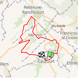

Length
13.6 km

Max alt
153 m

Uphill gradient
168 m
Km-Effort
15.9 km

Min alt
72 m

Downhill gradient
170 m
Boucle
Yes
Creation date :
2019-03-14 15:26:33.627
Updated on :
2019-03-14 17:26:34.131
3h28
Difficulty : Difficult

FREE GPS app for hiking
 SityTrail
IGN / Geographical institutes
SityTrail Plus
The world is yours!
About
Trail Walking of 13.6 km to be discovered at Hauts-de-France, Pas-de-Calais, Caucourt. This trail is proposed by Blourouce.
Positioning
Country:
France
Region :
Hauts-de-France
Department/Province :
Pas-de-Calais
Municipality :
Caucourt
Location:
Unknown
Start:(Dec)
Start:(UTM)
469522 ; 5583146 (31U) N.
Comments