


randogps62-280

Blourouce
User

Length
12.8 km

Max alt
191 m

Uphill gradient
154 m
Km-Effort
14.8 km

Min alt
113 m

Downhill gradient
154 m
Boucle
Yes
Creation date :
2019-03-15 16:25:48.559
Updated on :
2019-03-15 16:33:34.208
3h14
Difficulty : Difficult

FREE GPS app for hiking
 SityTrail
IGN / Geographical institutes
SityTrail Plus
The world is yours!
About
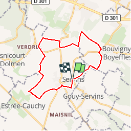
Trail Walking of 12.8 km to be discovered at Hauts-de-France, Pas-de-Calais, Servins. This trail is proposed by Blourouce.
Positioning
Country:
France
Region :
Hauts-de-France
Department/Province :
Pas-de-Calais
Municipality :
Servins
Location:
Unknown
Start:(Dec)
Start:(UTM)
474589 ; 5584241 (31U) N.
Comments