


preny

randolea
User
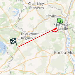

Length
22 km

Max alt
370 m

Uphill gradient
384 m
Km-Effort
27 km

Min alt
211 m

Downhill gradient
478 m
Boucle
No
Creation date :
2019-03-17 09:25:49.023
Updated on :
2019-03-17 12:35:22.226
2h33
Difficulty : Very easy

FREE GPS app for hiking
 SityTrail
IGN / Geographical institutes
SityTrail Plus
The world is yours!
About
Trail Walking of 22 km to be discovered at Grand Est, Meurthe-et-Moselle, Prény. This trail is proposed by randolea.
Positioning
Country:
France
Region :
Grand Est
Department/Province :
Meurthe-et-Moselle
Municipality :
Prény
Location:
Unknown
Start:(Dec)
Start:(UTM)
718965 ; 5429635 (31U) N.
Comments