


les tétines de Vernon

raab
User
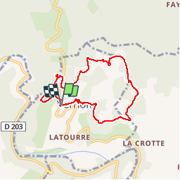

Length
7.5 km

Max alt
420 m

Uphill gradient
183 m
Km-Effort
9.9 km

Min alt
284 m

Downhill gradient
183 m
Boucle
Yes
Creation date :
2019-03-18 14:33:13.409
Updated on :
2019-03-18 17:24:23.335
2h50
Difficulty : Easy

FREE GPS app for hiking
 SityTrail
IGN / Geographical institutes
SityTrail Plus
The world is yours!
About
Trail Walking of 7.5 km to be discovered at Auvergne-Rhône-Alpes, Ardèche, Vernon. This trail is proposed by raab.
Positioning
Country:
France
Region :
Auvergne-Rhône-Alpes
Department/Province :
Ardèche
Municipality :
Vernon
Location:
Unknown
Start:(Dec)
Start:(UTM)
597095 ; 4928952 (31T) N.
Comments