


Revel.vol à voile st ferreok

leroj73
User
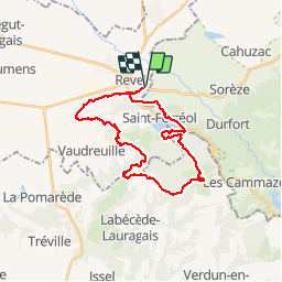

Length
28 km

Max alt
629 m

Uphill gradient
564 m
Km-Effort
36 km

Min alt
222 m

Downhill gradient
564 m
Boucle
Yes
Creation date :
2019-03-21 13:39:03.249
Updated on :
2019-03-22 10:42:18.586
1h49
Difficulty : Very easy

FREE GPS app for hiking
 SityTrail
IGN / Geographical institutes
SityTrail Plus
The world is yours!
About
Trail Mountain bike of 28 km to be discovered at Occitania, Haute-Garonne, Revel. This trail is proposed by leroj73.
Description
single. longue portion de rte
Positioning
Country:
France
Region :
Occitania
Department/Province :
Haute-Garonne
Municipality :
Revel
Location:
Unknown
Start:(Dec)
Start:(UTM)
420308 ; 4811786 (31T) N.
Comments
un peu de goudron.. de beaux singles 2 ou 3 passages technique.. un peu de poussée et voilà une jolie ballade par gré beau