


Parcours centre Yerres Brigitte

jeanmarcMasson
User GUIDE
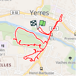

Length
3.3 km

Max alt
53 m

Uphill gradient
26 m
Km-Effort
3.6 km

Min alt
36 m

Downhill gradient
27 m
Boucle
Yes
Creation date :
2019-03-23 13:59:11.882
Updated on :
2019-03-28 11:19:41.395
2h51
Difficulty : Very easy

FREE GPS app for hiking
 SityTrail
IGN / Geographical institutes
SityTrail Plus
The world is yours!
About
Trail Walking of 3.3 km to be discovered at Ile-de-France, Essonne, Yerres. This trail is proposed by jeanmarcMasson.
Positioning
Country:
France
Region :
Ile-de-France
Department/Province :
Essonne
Municipality :
Yerres
Location:
Unknown
Start:(Dec)
Start:(UTM)
462326 ; 5395918 (31U) N.
Comments