


flagy

alexbnmr
User
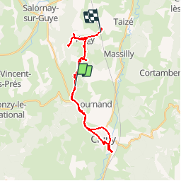

Length
36 km

Max alt
445 m

Uphill gradient
568 m
Km-Effort
44 km

Min alt
230 m

Downhill gradient
720 m
Boucle
No
Creation date :
2014-12-10 00:00:00.0
Updated on :
2014-12-10 00:00:00.0
5h18
Difficulty : Unknown

FREE GPS app for hiking
 SityTrail
IGN / Geographical institutes
SityTrail Plus
The world is yours!
About
Trail Other activity of 36 km to be discovered at Bourgogne-Franche-Comté, Saône-et-Loire, Flagy. This trail is proposed by alexbnmr.
Points of interest


Positioning
Country:
France
Region :
Bourgogne-Franche-Comté
Department/Province :
Saône-et-Loire
Municipality :
Flagy
Location:
Unknown
Start:(Dec)
Start:(UTM)
625136 ; 5147517 (31T) N.
Comments