


Apremont-la-forêt 2019

PhilippeC54
User
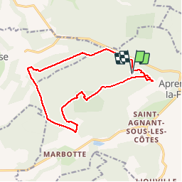

Length
14.6 km

Max alt
379 m

Uphill gradient
261 m
Km-Effort
18 km

Min alt
258 m

Downhill gradient
261 m
Boucle
Yes
Creation date :
2019-03-27 13:49:36.195
Updated on :
2019-03-27 18:08:50.592
2h06
Difficulty : Easy

FREE GPS app for hiking
 SityTrail
IGN / Geographical institutes
SityTrail Plus
The world is yours!
About
Trail Mountain bike of 14.6 km to be discovered at Grand Est, Meuse, Apremont-la-Forêt. This trail is proposed by PhilippeC54.
Positioning
Country:
France
Region :
Grand Est
Department/Province :
Meuse
Municipality :
Apremont-la-Forêt
Location:
Apremont-la-Forêt
Start:(Dec)
Start:(UTM)
691832 ; 5415220 (31U) N.
Comments