


Collioure banyuls par La Tour de la Madeloc

verotrail
User
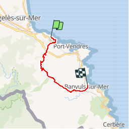

Length
15.5 km

Max alt
637 m

Uphill gradient
678 m
Km-Effort
25 km

Min alt
3 m

Downhill gradient
721 m
Boucle
No
Creation date :
2019-03-28 08:14:51.782
Updated on :
2019-10-21 12:07:17.027
6h25
Difficulty : Difficult

FREE GPS app for hiking
 SityTrail
IGN / Geographical institutes
SityTrail Plus
The world is yours!
About
Trail Walking of 15.5 km to be discovered at Occitania, Pyrénées-Orientales, Collioure. This trail is proposed by verotrail.
Description
Collioure banyuls par la madeloc
Positioning
Country:
France
Region :
Occitania
Department/Province :
Pyrénées-Orientales
Municipality :
Collioure
Location:
Unknown
Start:(Dec)
Start:(UTM)
506475 ; 4708581 (31T) N.
Comments