


Givenchy 12 km

Blourouce
User
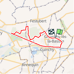

Length
11.9 km

Max alt
34 m

Uphill gradient
89 m
Km-Effort
13.1 km

Min alt
15 m

Downhill gradient
90 m
Boucle
Yes
Creation date :
2019-03-28 18:38:54.714
Updated on :
2019-03-28 18:46:37.108
2h57
Difficulty : Difficult

FREE GPS app for hiking
 SityTrail
IGN / Geographical institutes
SityTrail Plus
The world is yours!
About
Trail Walking of 11.9 km to be discovered at Hauts-de-France, Pas-de-Calais, Givenchy-lès-la-Bassée. This trail is proposed by Blourouce.
Positioning
Country:
France
Region :
Hauts-de-France
Department/Province :
Pas-de-Calais
Municipality :
Givenchy-lès-la-Bassée
Location:
Unknown
Start:(Dec)
Start:(UTM)
482796 ; 5597503 (31U) N.
Comments