


ailhon merzelet

raab
User
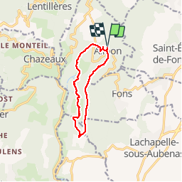

Length
10.2 km

Max alt
504 m

Uphill gradient
223 m
Km-Effort
13.1 km

Min alt
380 m

Downhill gradient
221 m
Boucle
Yes
Creation date :
2019-03-28 13:16:22.219
Updated on :
2019-03-29 14:34:29.318
3h32
Difficulty : Easy

FREE GPS app for hiking
 SityTrail
IGN / Geographical institutes
SityTrail Plus
The world is yours!
About
Trail Walking of 10.2 km to be discovered at Auvergne-Rhône-Alpes, Ardèche, Ailhon. This trail is proposed by raab.
Positioning
Country:
France
Region :
Auvergne-Rhône-Alpes
Department/Province :
Ardèche
Municipality :
Ailhon
Location:
Unknown
Start:(Dec)
Start:(UTM)
606488 ; 4939306 (31T) N.
Comments