


Bord Yerres-Lieusaint 35 Km

jeanmarcMasson
User GUIDE
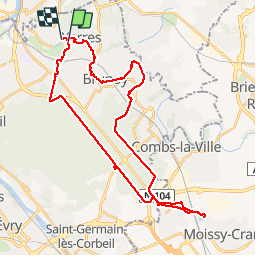

Length
35 km

Max alt
102 m

Uphill gradient
276 m
Km-Effort
39 km

Min alt
32 m

Downhill gradient
275 m
Boucle
No
Creation date :
2019-03-31 08:09:30.57
Updated on :
2019-03-31 12:40:51.671
4h28
Difficulty : Easy

FREE GPS app for hiking
 SityTrail
IGN / Geographical institutes
SityTrail Plus
The world is yours!
About
Trail Road bike of 35 km to be discovered at Ile-de-France, Essonne, Yerres. This trail is proposed by jeanmarcMasson.
Positioning
Country:
France
Region :
Ile-de-France
Department/Province :
Essonne
Municipality :
Yerres
Location:
Unknown
Start:(Dec)
Start:(UTM)
461678 ; 5395879 (31U) N.
Comments