


les crêtes de Saint-Andéol-de-Berg

raab
User
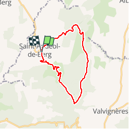

Length
13.5 km

Max alt
505 m

Uphill gradient
363 m
Km-Effort
18.3 km

Min alt
306 m

Downhill gradient
361 m
Boucle
Yes
Creation date :
2019-04-01 07:56:15.858
Updated on :
2019-04-01 13:36:25.068
4h43
Difficulty : Easy

FREE GPS app for hiking
 SityTrail
IGN / Geographical institutes
SityTrail Plus
The world is yours!
About
Trail Walking of 13.5 km to be discovered at Auvergne-Rhône-Alpes, Ardèche, Saint-Andéol-de-Berg. This trail is proposed by raab.
Positioning
Country:
France
Region :
Auvergne-Rhône-Alpes
Department/Province :
Ardèche
Municipality :
Saint-Andéol-de-Berg
Location:
Unknown
Start:(Dec)
Start:(UTM)
621408 ; 4931758 (31T) N.
Comments