


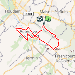
Olhain Rebreuve

Blourouce
User

Length
11.4 km

Max alt
193 m

Uphill gradient
188 m
Km-Effort
13.9 km

Min alt
63 m

Downhill gradient
186 m
Boucle
Yes
Creation date :
2019-04-01 14:03:09.587
Updated on :
2019-04-01 14:17:31.634
3h10
Difficulty : Difficult

FREE GPS app for hiking
 SityTrail
IGN / Geographical institutes
SityTrail Plus
The world is yours!
About
Trail Walking of 11.4 km to be discovered at Hauts-de-France, Pas-de-Calais, Maisnil-lès-Ruitz. This trail is proposed by Blourouce.
Positioning
Country:
France
Region :
Hauts-de-France
Department/Province :
Pas-de-Calais
Municipality :
Maisnil-lès-Ruitz
Location:
Unknown
Start:(Dec)
Start:(UTM)
469741 ; 5587994 (31U) N.
Comments