


9763657-EC-P2

PhilippeC54
User
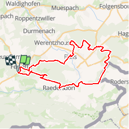

Length
33 km

Max alt
638 m

Uphill gradient
818 m
Km-Effort
44 km

Min alt
382 m

Downhill gradient
821 m
Boucle
Yes
Creation date :
2019-04-02 15:40:49.94
Updated on :
2019-04-02 15:42:15.855
--
Difficulty : Medium

FREE GPS app for hiking
 SityTrail
IGN / Geographical institutes
SityTrail Plus
The world is yours!
About
Trail Mountain bike of 33 km to be discovered at Grand Est, Haut-Rhin, Bendorf. This trail is proposed by PhilippeC54.
Positioning
Country:
France
Region :
Grand Est
Department/Province :
Haut-Rhin
Municipality :
Bendorf
Location:
Unknown
Start:(Dec)
Start:(UTM)
372733 ; 5261047 (32T) N.
Comments