


9764610-Levoncourt

PhilippeC54
User
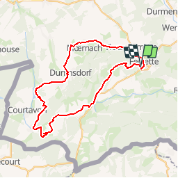

Length
30 km

Max alt
651 m

Uphill gradient
662 m
Km-Effort
39 km

Min alt
435 m

Downhill gradient
685 m
Boucle
Yes
Creation date :
2019-04-02 15:45:41.735
Updated on :
2019-04-18 16:19:55.838
--
Difficulty : Unknown

FREE GPS app for hiking
 SityTrail
IGN / Geographical institutes
SityTrail Plus
The world is yours!
About
Trail Mountain bike of 30 km to be discovered at Grand Est, Haut-Rhin, Ferrette. This trail is proposed by PhilippeC54.
Positioning
Country:
France
Region :
Grand Est
Department/Province :
Haut-Rhin
Municipality :
Ferrette
Location:
Unknown
Start:(Dec)
Start:(UTM)
372762 ; 5261029 (32T) N.
Comments