


9763584-Abbaye de Lucelle

PhilippeC54
User
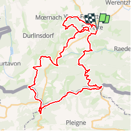

Length
46 km

Max alt
751 m

Uphill gradient
1308 m
Km-Effort
64 km

Min alt
479 m

Downhill gradient
1307 m
Boucle
Yes
Creation date :
2019-04-02 15:57:46.216
Updated on :
2019-04-02 15:58:22.373
--
Difficulty : Difficult

FREE GPS app for hiking
 SityTrail
IGN / Geographical institutes
SityTrail Plus
The world is yours!
About
Trail Mountain bike of 46 km to be discovered at Grand Est, Haut-Rhin, Ferrette. This trail is proposed by PhilippeC54.
Description
Parcours P6
Positioning
Country:
France
Region :
Grand Est
Department/Province :
Haut-Rhin
Municipality :
Ferrette
Location:
Unknown
Start:(Dec)
Start:(UTM)
373548 ; 5261203 (32T) N.
Comments