


9763399-Waldighofen

PhilippeC54
User
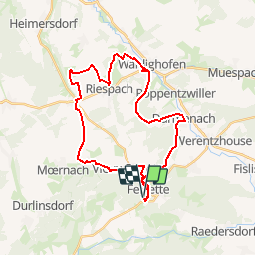

Length
31 km

Max alt
588 m

Uphill gradient
588 m
Km-Effort
38 km

Min alt
343 m

Downhill gradient
592 m
Boucle
Yes
Creation date :
2019-04-05 09:23:28.591
Updated on :
2019-04-05 09:25:02.752
--
Difficulty : Medium

FREE GPS app for hiking
 SityTrail
IGN / Geographical institutes
SityTrail Plus
The world is yours!
About
Trail Mountain bike of 31 km to be discovered at Grand Est, Haut-Rhin, Bendorf. This trail is proposed by PhilippeC54.
Description
Parcours #11
Caserne pompiers Waldighofen
Musée sapeurs pompiers Vieux-Ferrette
Positioning
Country:
France
Region :
Grand Est
Department/Province :
Haut-Rhin
Municipality :
Bendorf
Location:
Unknown
Start:(Dec)
Start:(UTM)
372726 ; 5261086 (32T) N.
Comments